X-Air Adventures
Breaking Down The Barriers Story by Michael Coates
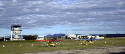
The 14th of May dawned as a rather ordinary looking day, the cloud was low, the valleys filled with fog and a light rain was falling as a fine mist. With the temperature barely into double figures it was a typical morning heralding the start of winter. Our minds were focused on warmer climates and our first opportunity to do some coastal flying in the X-Air’s that were normally based in central NSW at Mudgee.
8.25 am saw our departure into the gloom which I really thought would close in before we hit the Hunter Valley and force our return to the Mudgee Aerodrome, a pair of X-Air’s departed overhead Mudgee tracking for Wollar, Denman and our first re-fuelling at Maitland.
The weather on the coast promised to be better than what we were flying in as we checked with a fellow X-Airian just after 7.00 am and got a reasonably favorable forecast, we flew on passing over familiar territory until we hit the Munghorn Gap just south of Wollar. The Munghorn is a strange place, calling the hill tiger country is being kind, it's a mixture of thick scrub and sandstone outcrops, a sole road leads through the middle with a major power line parallel about 1 km to the East. Standing on the gap itself I have been told by a local National Parks ranger – that a cup of water spilt this way will go on through the Hunter Valley to Newcastle and one step the other direction the same cup of water would travel through to the Murray exit thousands of kilometers away, interesting stuff I thought to myself as we passed over the gap and onto the flatter and more forgiving farming country in the Bylong valley.
Our main point of reference for the trip down the Hunter Valley was the railway line running from the Ulan Coal Mine to the Port of Newcastle. My Garmin GPS Pilot III is an amazing piece of equipment, and while I never rely on it to be my main source of navigation I always am comfortable knowing I can use it in the case of emergency, The security of using the moving map display against your own maps means there is never any excuse for not knowing exactly where you are. The unit continues to amaze me with it’s incredibly detailed database and the fact it can display accurate times to the next waypoint without using the old whiz wheel and ruler.
Phil flying the newly released X-Air with flaps was enjoying the adventure because he had never flown down the Hunter Valley before, chatting almost non stop on the radio’s the time flew past until we could see Mt Dangar at Denman. Denman is home to the giant Rosemount Wine facility and also the largest underground ammunition store in the southern hemisphere, a sole railway track leaves the main line and departs under the hill, the area is surrounded by about 50 buildings and a pretty high fence around the underground entry. The extent of the underground complex can be gauged by the exhaust fans that vent stale air to the surface, these are clearly visible in the cold morning air, it’s a huge place.
|
Passing just south of Denman we could see a lot of fog coming down the valley from up Tamworth way and I knew from the radio chatter on the area frequency that all the inland airports were shutdown for the morning. After a brief discussion with Phil we decided to reverse track and land at the Rosemount airstrip and wait for the slowly appearing sun to burn off the fog. |
The Rosemount strip borders on the permanent restricted zone R533 and the strip is unique that you can only land and take off from one direction or you will infringe the restricted zone. A one-hour wait and a quick call to the flying school at Maitland saw our departure to Singleton again skirting the Dochra military zone and we arrived in Maitland in near perfect conditions.
There are two ways around the Williamtown airbase one is called the VFR coastal route, which follows the coast at 500 feet ASL from Nobby’s Head to Sugarloaf Point and the other is the inland lane which again follows the main rail line from Maitland to Dungog, Glouster and then tracking north east towards the coast to meet up with Taree.
Some more interest was added to our trip as the Notam’s warned of low-level jet activities over our planned inland route. The Inland lane follows the railway line north and there are several restrictions on it’s use, one is you cant stray more than 1 nautical mile from the railway centerline in either direction and the other is a height restriction, the first part of the lane from Maitland to Dungog only allows for a maximum vertical height of 1000 feet AMSL (above mean sea level) and the rest of the lane only provides for a maximum height of 1500 feet AMSL. The ERSA has a warning that during activity periods military aircraft will avoid the corridor by a minimum altitude of 500 feet, interesting stuff as we flew north from Maitland always vigilant of the altimeter, our position in the lane and the chance of doing ‘combat’ with an F18 at close quarters. Unfortunately they must have been off doing something else as all we spotted was beautiful countryside.
Landing at Taree airport was welcome after the long and mentally exhausting leg from Maitland (it takes a lot out of you looking for the elusive F18’s), the 15-knot headwind up the inland lane meant we could not make Port Macquarie on our fuel supply without adequate reserves. The biggest problem with flying is the availability of fuel, I do a lot of inland flying and seem to always be able to find an avgas bowser that will accept BP carnet, only problem on the coast is they all seem to be Shell bowsers, one day I hope they will universally be able to take credit card ! (fuel Company’s note). The ERSA listed phone numbers for the agents and guess what…. of the three numbers listed two were disconnected and the other was engaged for over two hours !, not a good way to do business. Finally we found someone who turned up and knew where the key was to fill us up and get on the way…. Over two hours behind schedule.
I have titled this story as "Breaking Down The Barriers" and the next part of our adventure was taking us into a Primary Control Zone and a GAPP airport !, things not normally done in an Ultralight registered aircraft. The trip north from Taree was fantastic, passing all the little beaches and towns as we tracked coastal at 1000ft we were off on the chat channel again talking to each other as we passed the miles away.
We have always used the frequency 123.45 for our aircraft to aircraft chatting as I was told when I did my training that it’s a dedicated channel allocated for air to air conversation, it’s easy to remember and we have used it for years, well I was quite surprised to hear the near heavenly voice come over the radio. “Stations on this channel please identify yourselves…. Ahh this is X-Air 231 and 278 tracking coastal north of Taree. X-Air 231 are you a boat ?, Negative we are two Ultralight Aircraft tracking coastal north of Taree, X-Air 231 G'day guys this is Captain ?? flying a Jumbo from Sydney to Fiji you guys are booming in what type of radio's are you using. Well it seems that there has been a change recently in that frequency which had not made it into the AIP’s, it seems the channel is now available to intercontinental aircraft for there use also, we had a good 10 minute conversation with the pilot of the jumbo and he confirmed he was at 33,000 feet approx 300 miles from Sydney on route to Fiji, he was absolutely amazed at how good our Microair radios were performing and he initially thought we were coast guard surveillance vessels at sea. Even in the loud environment of an Ultralight cockpit he could barely hear any engine noise above our voices, they are really good radios and I highly recommend them.
Passing Port Macquarie, Kempsey and on to Nambucca heads where we were required to report in. Our entry into controlled airspace was already approved a couple of days ago and our flight notification was lodged with Air Services before we left Taree. Changing from the area frequency to Coff's tower the conversation went something like this.....
Coff's Tower X-Air 231,
X-Air 231 Coff's Tower Go Ahead.
Good afternoon Coff's tower. X-Air 231 accompanied in loose formation by X-Air 278, currently abeam Nambucca Heads tracking north coastal at 1000 ft over water at all times, received Charlie (ATIS) requesting airways clearance.
X-Air Formation good afternoon, remain coastal over water no higher than 1000 ft report abeam Sawtell.
That's it we were now cleared to continue into controlled airspace and report again at Sawtell. The ATIS which I acknowledged receiving is a recorded information service, it's a bit like a telephone answering machine that continuously broadcasts the current conditions at the airport, from this information we can tell which runway is in use the wind direction and speed the rainfall and any other relevant information.
Arrival at Coff's was under the direction of the air-traffic controller and clearance was granted to land and taxi to the general aviation tie down area. What a day of contrasts, we had gone from winter weather, fog and rain to clear blue skies – shorts and tee shirt weather. The planes were fuelled and prepared for the next day’s flight to Coolangatta.
A 6.40 departure from Coff’s had us leaving in perfect weather except for that nagging 15-knot head wind which slowed our progress north. The run coastal in the early morning was as good as it gets. Still air, people on the beaches out for a morning run "Ahh life's good". Our next reporting spot was at Yamba where we contacted Brisbane Central, I am particularly wary about flying through the Evans Head Military Zone without checking first, my last trip through here was in a 182 and they activated the zone between when I left Mudgee and getting to Coff's so it didn't make the Notam I got that morning. I was quite happily flying the 182 along when I could see jet traffic in front of me, I immediately contacted Brisbane to be told they activated the area for bombing practice two hours earlier !. No problems for the X-Air's this time though as it was shut down till Monday afternoon.
Re-fueling at Ballina (again waiting for fuel and paying the $20 call out fee) we headed North past Lennox Head and rounded the lighthouse at Byron Bay, the coast was now much more populated and vegetated than the previous couple of hours and the air was buoyant and warm compared to inland NSW. Abeam Hastings point we contacted Cooly Tower direct as instructed for our approach briefing, normally you would go through Brisbane Radar, but as we had special clearance we did as we were instructed.
 |
Cooly Tower had us to descend to 500 AGL for the final 10 miles into Coolangatta, we tracked over the beaches to Cook Island and passed the Tweed River before being given a visual approach and then clearance to land. Our final crossing of the coast which was on some sort of base leg had a couple of 737’s or Airbuses go nearly directly overhead, and I laughed to myself at what the pilots and passengers thought at our little yellow planes passing by the side windows. Cooly Tower to X-Air formation "B1 and B2” your clear to land". The comment went right over my head until I landed when it suddenly hit me. The Air Traffic Controller had nicknamed us B1 and B2 because we were both yellow after the Bananas in Pajamas. |
Touchdown at Cooly and a change from Cooly Tower frequency to Coolly Ground had instructed "B1 and B2" to taxi to the general aviation tie down areas for refueling and pats on the back all round. We had just organized fuel when the airport operations security manager came over in a security car, lights flashing, I suddenly had all these bad thoughts going through my mind when we were greeted "Welcome to Coolangatta".. Phew. We talked for about 20 minutes on how much does it cost to buy, how long to build, what sort of license etc, where do I get one…. Better check with the wife first…. The manager was that impressed with our aircraft he was waiting at the end of the main runway early the next morning to watch our departure. We then finished securing the planes for our overnight stay.
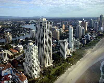
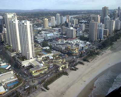
The next day was to be our last with the run up the coast to Caboolture where both planes are residing for a while. Leaving Coolangatta and tracking North coastal over water at 500 feet is one of the best things I have ever done, you can barely imagine the feeling of thousands of people on the beach all waving to you and passing the skyscrapers at Surfers was a great thrill. Flying along you can see into the units and wave to people eating breakfast on the balcony’s, some of the big high-rises are over 500 feet high and taller than we were flying, they did create quite a bit of turbulence as wind passed between them. We tracked North through the Southport MBZ passing Sea World and South Stradbroke Island, then over to Jacobs Well Airfield where we hoped to meet a couple of the locals. Unfortunately the 15 to 25 knot North Westerly had restricted all the activity at the field and it was deserted, we made the decision not to land to conserve fuel in the head wind and track back to the coast and on to North Stradbroke Island. The crossing between North Strady and Moreton Island is not that far but with a good 20 knot head wind it seemed to take forever, it’s a really pretty place and I am defiantly going back there fishing one day.
 |
Once over land on Moreton Island we again descended back down to 500 AGL, my theory was to hide in the wind shadow of Moreton Island and pick up an extra few knots over the ground, this worked as the GPS showed an increase of almost 15 knots on the ground speed we had been achieving at 1500 feet. Moreton Island also deserves a closer look as time permits, tracking along over the beach it was possible to see the concrete remains of gun emplacements in the dunes put in to protect Brisbane of invasion throughout the war, I personally though all the sand bars would do the trick and stop any good sized boat. |
We climbed to 1500 feet at Cape Moreton and turned to head almost due west to our final destination of Caboolture, the strong winds had now swung round to almost due west and slowed our progress dramatically, Phil then suggested we climb a bit higher and see what’s happening up top, so with that we climbed to 3500. The air was dead smooth at 3500, the visibility was now endless and the strong head wind at 1500ft was now almost now existent. The crossing of the Great Sandy Straight was our last hurdle to overcome, at about half way across your concentration is complete…. Did the EGT just move a bit ??, how's the fuel going, did I see another plane, what’s that strange noise I can hear…. Can I swim !!, if the noise stops will I make it to shore under glide ??? all these things and more flash through your head at a great rate, it makes me wonder how the pilot who flew from Tassy to New Zealand went !!.
Arrival at Caboolture was almost an anti-climax compared to what we had achieved, I really felt by landing at Coff’s Harbour and at Coolangatta we had broken down the barriers between Ultralight Aircraft and General Aviation just a little bit more, the people we spoke to at the airports were full of interest of our aircraft and could not believe the way these little aircraft went.
It must be noted before all the do gooders get on the phone that both pilots held full-unrestricted PPL licenses with GAPP clearance and that our adventure into the controlled areas was pre arranged and approved prior to our flight.
Now.. Where are we off to next ?..